Snow Signal Pacific
ENSO · MJO · PNA · Jet Stream · Satellite — 北太平洋滑雪氣候情報中心
Live imagery
ENSO / Live NOAA CPC
LOADING… NOAA
正在讀取 NOAA ENSO observation、RONI 與官方機率 outlook…
Weekly Niño 3.4
—
latest weekly anomaly
Monthly Niño 3.4
—
relative Niño 3.4
Latest RONI
—
3-month relative index
Weekly trend
—
loading
Niño 3.4 — last 12 weeks
Weekly relative SST anomaly
—
Official NOAA ENSO probability outlook
—| Season | La Niña | Neutral | El Niño |
|---|---|---|---|
| Loading NOAA probabilities… | |||
Intraseasonal & Teleconnection
每天到數週尺度MJO — Live Observation
JMA RMM index · NOAA CPC phase diagram
Loading…JMA RMM index · NOAA CPC phase diagram
Current phase
—
JMA
Region
—
RMM phase region
Amplitude
—
loading
Trend
—
3-day amplitude change
BC Interpretation
正在讀取 JMA MJO 資料…

圖中離中心越遠代表 MJO amplitude 越強。上方數值由 Snow Signal API 自動解析;這裡先做 observation,下一階段再加入 GEFS / ECMWF MJO forecast。
PNA — Live Observation + GEFS Forecast
NOAA CPC · live observed index + ensemble forecast
NOAA CPC · live observed index + ensemble forecast
PNA: —Loading…
Current PNA
—
NOAA CPC
7-day average
—
observed mean
7-day change
—
loading
BC Interpretation
正在讀取 NOAA CPC PNA 資料…
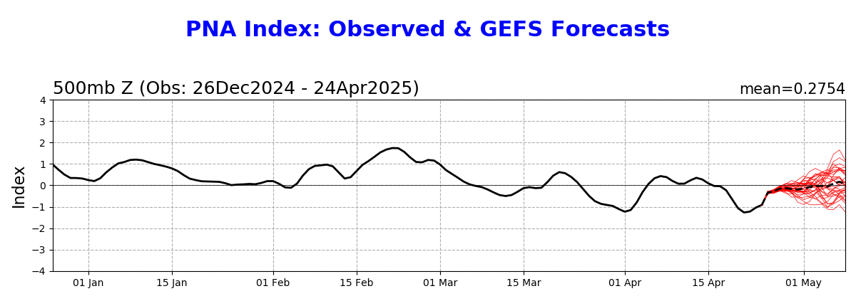
上方數字由 Snow Signal 的 Vercel Function 自動讀取 NOAA CPC 觀測 CSV;圖片則保留 GEFS ensemble forecast。之後我們會再解析 GEFS CSV,加入真正的 7–14 天 forecast score。
North Pacific Flow
風暴路徑與高空氣流Jet Stream — Live 250 hPa Analysis
NOAA GFS via Open-Meteo · Snow Signal jet detector
NOAA GFS via Open-Meteo · Snow Signal jet detector
BC: —Loading…
Current jet core
—
250 hPa
Core speed
—
loading
Flow
—
wind direction
72h core
—
forecast trend
Jet core latitude — next 72 hours
Higher latitude = farther north
—
| Forecast | Core latitude | Speed | BC signal |
|---|---|---|---|
| Loading GFS jet analysis… | |||
BC Interpretation
正在分析 North Pacific 250 hPa jet…

上方數值是 Snow Signal 對 GFS 250 hPa wind 的第一版自動分析;Air Mass RGB 則提供即時大尺度視覺背景。Jet detector 目前是 21 個取樣點的 v0.1,後續會升級成 2D jet-axis analysis。
GOES-West Satellite
Northern Pacific · GeoColor
LiveNorthern Pacific · GeoColor

用來直接看 North Pacific storm train、低壓系統、雲帶與進入 BC coast 的水氣結構。後續可以加 water vapor 與 atmospheric river layer。
Satellite History
GOES-West · 每日固定時間 · 最近 7 天Pacific Satellite — 7-Day History
NOAA GOES-18 · Vancouver local time
NOAA GOES-18 · Vancouver local time
Loading…
How to read this
GeoColor is best for cloud/storm evolution. Snow/Ice Band 5 can support snow/ice identification, but cloud can hide the ground and this is not a snow-depth measurement.
Surface Snow Cover
MODIS daily overview · Sentinel-2 high resolutionBC / Whistler Daily Snow Cover
NASA MODIS Terra · ~500 m
Loading…
NASA MODIS Terra · ~500 m
MODIS is the broad daily overview. It is useful for seeing where snow cover is expanding across BC, but ~500 m pixels are too coarse for individual ski runs and cloud can hide the surface.
Whistler High-Res Snow Monitor
Copernicus Sentinel-2 L2A · 10–20 m source resolution
Loading…
Copernicus Sentinel-2 L2A · 10–20 m source resolution
Available Sentinel-2 Passes
Whistler Satellite Snow Coverage Trendclear visible terrain only
Loading recent snow coverage…
Sentinel-2 is the detailed resort view. Click any available pass to switch dates. “Snow coverage” is the percentage of visible valid terrain classified as snow inside our current Whistler/Blackcomb monitoring box. It is not snow depth and is not yet restricted to terrain above 1,800 m or the exact ski-area boundary.
Whistler Mountain Weather
GFS · 0–7 天雪場預報Whistler Blackcomb — Live Mountain Forecast
Village 675 m · Roundhouse 1,850 m · Peak 2,182 m
Village 675 m · Roundhouse 1,850 m · Peak 2,182 m
SNOW: —Loading…
Peak temperature
—
2,182 m
Next 24h snow
—
modelled snowfall
Next 72h snow
—
modelled snowfall
Freezing level
—
loading
Peak modelled snowfall — next 7 days
GFS snowfall estimate at 2,182 m
—
| Elevation | Temp | Wind | 7d snow |
|---|---|---|---|
| Loading mountain levels… | |||
850 hPa temperature
—
lower-atmosphere thermal profile
72h avg freezing level
—
storm snow-line context
Whistler Interpretation
正在分析 Whistler mountain temperature、snowfall 與 freezing level…
| Date | Peak snow | Peak temp | Freezing level avg | Precip chance |
|---|---|---|---|---|
| Loading 7-day forecast… | ||||
Snowfall 是 GFS modelled snowfall,不是雪場實測新雪。這一層會在下一步和 ENSO、MJO、PNA、Jet Stream 融合,產生 Snow Signal Score、Powder Potential 與 Best Ski Day。
Blackcomb Mountain — Snow Signal 2D Map
Perspective resort view · clickable runs · GPS map preservedBlackcomb Mountain2D terrain · skier view · 90°
Overview
Official-map audit · geometry corrected
Confirmed duplicate geometry removed · Easy Out fully merged
Confirmed duplicate geometry removed · Easy Out fully merged
Zoom in for more trail detail · names appear on selection
Map Cleanup Mode
Blackcomb Map Cleanup
Use this only for confirmed map corrections. Normal users never see this panel.
Confirmed geometry
These confirmed corrections are now applied to the normal main map.
✓ Sunset Boulevard → Easy Out → Sunnyside Up
✓ Everglades duplicate component removed
✓ Expressway duplicate component removed
✓ Everglades duplicate component removed
✓ Expressway duplicate component removed
Exact phantom-feature cleanup
Click the bad line itself. For trails, only the clicked geometry component (lineIndex) is marked — never the whole official run.
Nothing selected
Green
Blue
Black / Expert
Lift
Selected run
Snow Signal Resort Map uses stored GIS geometry plus a custom landmark-based layout calibration so Whistler and Blackcomb read more like a skier trail map. It is not a copy or tracing of Whistler Blackcomb's official artwork and is not intended for emergency, closure or avalanche navigation.
Best Runs Right Now
Deterministic Snow Signal ranking · current map viewAnalyze the current resort view
Ranks a small representative set using the existing trail-condition engine. No AI guessing.
Ready
Choose Whistler, Blackcomb, or a pull-out area above, then analyze the best representative runs in that view.
MVP scope: this does not yet score every official run. It evaluates a limited set of representative mapped runs to validate ranking logic before we build the full server-side recommendation engine.
Whistler Trail Conditions
Named run · aspect-aware hourly surface forecastTerrain Snow Condition Engine / Named Run
Harmony Ridge
搜尋 Whistler 雪道名稱,查看依坡向、太陽角度與每小時天氣推估的雪面狀態。
Difficulty
—
OSM piste difficulty
Grooming
—
when mapped
Aspect
—
approx downhill heading
Reference elevation
—
whole-run reference elevation
Slope model
—
whole-run reference
Length
—
mapped piste length
Best window
—
today
Softening after
—
solar / thermal estimate
Slushy risk after
—
if melt threshold is reached
Refreeze / ice after
—
freeze-thaw estimate
Upper / Middle / Lower terrain
DEM-derived elevation + slope · segment-specific aspect
Loading segment terrain…
Whole-run hourly reference · 08:00–16:00
Loading Harmony Ridge…
Trail Interpretation
Select a named run to calculate today's aspect-aware surface conditions.
Select a named run to calculate today's aspect-aware surface conditions.
Upper / middle / lower are equal-distance thirds of the mapped piste. Each segment now uses its own DEM-derived elevation, slope and aspect; official resort section boundaries, grooming changes, shade and microterrain are still future refinements.
下一階段:Snow Signal Score + AI Interpretation
把所有訊號融合成滑雪決策ENSO
Season
背景:數月尺度
MJO / PNA
2–4 wk
型態轉換與可預測窗口
Jet / Storm track
7–14 d
風暴路徑與 ridge/trough
Mountain weather
0–7 d
雪量、雪線、風、SWE
最後會把四層訊號融合,輸出例如:Whistler Powder Probability、Snow Quality、Freezing Level Risk、Wind Hold Risk、Best Ski Day,而不是讓使用者自己讀十張氣象圖。